Biological monitoring has been carried out in Irish rivers since 1971. The current national river monitoring programme covers more than 13,000 km of river channel.
The national rivers monitoring programme is run by the EPA and focuses on the main river channels, rather than smaller streams.
The programme includes more than 2,800 sites sampled for biology.
Almost half of these are also sampled for physical (e.g. oxygen content) and chemical (e.g. nitrogen and phosphorus) parameters.
What is monitored?
The biological monitoring assesses:
- Invertebrates (animals without a backbone, such as mayflies or worms)
- Aquatic plants
- Diatoms (a type of algae)
- Fish (monitored by Inland Fisheries Ireland)
The physical and chemical parameters measured in the field and laboratory include:
- Dissolved oxygen
- Nutrients, such as nitrogen and phosphorus
- Hazardous substances
- Temperature
- pH (acidity)
The hydrological parameters include water level and flow.
The biology is monitored once every three years, while the physical and chemical parameters are measured several times a year.
EPA monitor river levels and flows continuously and any changes in the physical structure of the river channel are also recorded.
For technical information on EPA survey methods and detailed monitoring programme, see report.
Suggests that EPA resources should / could be reallocated to most at risk monitoring locations
The (2019-2021) review has highlighted the need to make the programme more dynamic and responsive to environmental change.
This has been achieved by increasing the frequency of monitoring at sites which have been damaged by pollution or are at risk of not meeting their environmental objectives.
These sites include high status water bodies that are at risk of deterioration, or that have already deteriorated and water bodies that have been impacted by suspected toxic (chemical pollution) events.
To make the programme more dynamic, consideration will be given to the removal of water bodies from the operational network once their objectives have been met and can be maintained and to redeploy this monitoring resource elsewhere.
co-chemical and biological monitoring networks to achieve a more spatially integrated assessment of ecological status.
Increased frequency of monitoring of high status sites at risk of not meeting their environmental objectives and those which have already deteriorated including annual monitoring at the remaining highest quality sites (Q5).
Increased frequency of monitoring at sites suspected of being impacted by toxic events including annual monitoring until improvement in status is detected.
Establishment of an acid sensitive area network to assess the impact of acidification.
Establishment of a WFD specific climate change network to understand the effects of climate change on macroinvertebrate communities, reference condition and assessment.
Nominated authorities for elements of the surveillance and operational monitoring programmes

Distribution of risk across each of the five individual water categories

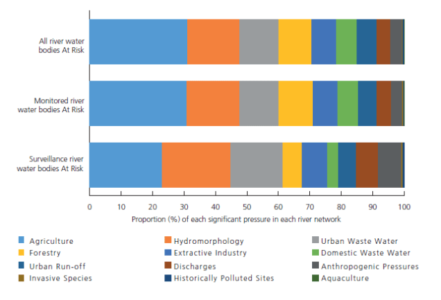
Representation of significant pressures in the rivers monitoring programme
Priority substances and priority hazardous substances (italicised) listed in the Priority Substances Directive (2013/39/EC) together with an indication of the substances and matrices being monitored in the national WFD monitoring programme.


Number of water bodies in each operational subnetwork by surface water category in the national WFD monitoring programme 2019-2021.

Note:
The data collected in the national monitoring programme can be viewed and analysed within the WFD Application. The WFD App, for short, provides a single point of access not only to monitoring data but to a database of GIS referenced catchment layers.
The Application is accessible through EDEN https://wfd.edenireland.ie/ and is available to EPA staff and EPA-funded researchers, as well as staff in other public agencies
As a member of the public you can apply for access to EDEN, but it is not clear if may people do. Ideally, the data would be in an open format, with an easy to access user interface, so anyone could check the data on their local river.