Graney Demonstration Catchment Desk Study

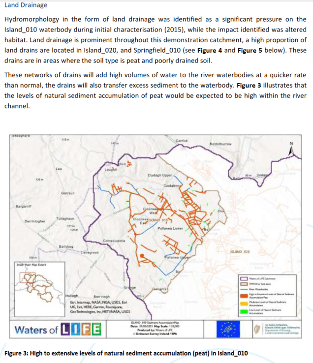
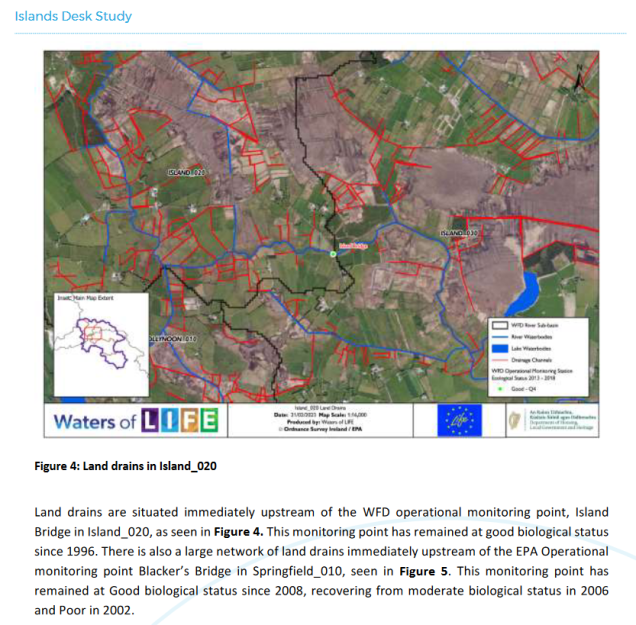
The Desk Study for the Graney Demonstration Catchment in on the borders of Counties Clare and Galway has been published.

The Desk Study was prepared by Local Authority Waters Programme (LAWPRO) catchment scientists on behalf of the Waters of LIFE Project.

Desk Studies are the first stage in Project Action C1: Catchment Walkover Investigations. They are the initial investigations of the catchments based on a range of available data sources.

These include OSi mapping and orthophotography, EPA status, risk assessment and pressure datasets, CORINE land cover mapping, Forest Service and Coillte data on forest activities and Geological Survey of Ireland (GSI) data on Soils and geology.

These data are collated into one report detailing the current conditions within the catchments, and listing any potential pressures and threats to water quality within them.

This is the sixth and final Desk Study published by the project.

See Graney Desk Study for full details.

The Graney was selected as one of the five demonstration catchments primarily due to the presence of high forest cover on High status objective rivers

Islands Demonstration Catchment Desk Study

17.5.23

The Desk Study for the Islands Demonstration Catchment in on the borders of Counties Roscommon and Galway has been published.

The Desk Study was prepared by Local Authority Waters Programme (LAWPRO) catchment scientists on behalf of the Waters of LIFE Project.

Desk Studies are the first stage in Project Action C1: Catchment Walkover Investigations.

They are the initial investigations of the catchments based on a range of available data sources.

These include OSi mapping and orthophotography, EPA status, risk assessment and pressure datasets, CORINE land cover mapping, Forest Service and Coillte data on forest activities and Geological Survey of Ireland (GSI) data on Soils and geology.

These data are collated into one report detailing the current conditions within the catchments, and listing any potential pressures and threats to water quality within them.This is the fifth Desk Study published by the project.

LAWPRO has drafted a referral to Irish Water outlining the concerns above. Under Irish Water’s River Basin Management Plan Enhanced Ambition Programme, Ballymoe WWTP will be upgraded, with the upgrades due to be completed by 2025.

Priority Action Areas in which LAWPRO fieldwork is underway

(As at March 2022)

Note from LAWPRO: the numbers referred to in the LAWPRO annual report are for fieldwork underway in priority areas for action (PAAs) and the reference to “complete” was made in error. In-stream assessment fieldwork is a complex process that takes place in phases over a number of seasons and in many cases over a number of years. Fieldwork is not complete until an action plan has been finalised. Once fieldwork in a PAA is complete and an action plan is available, it will be published on http://www.catchments.ie or http://www.lawaters.ie.

This record lists the PAAs in which fieldwork is underway.

PAA Name
Rogerstown Estuary
Allow
Owveg (Nore)
Milltown (Kerry)
Silver (Kilcormac)
Athy stream
Kilmainham (Dee)
Lough Ennel/ Dysart Stream
Camlin
Moynalty
Clonshanbo/ Lyreen
Potters and Three Mile Water
Erne
Burren
Bundorragha
Lough Melvin and Drowse
Clonakilty
Glen Lackagh
Owenriff
Rosscarbery
Upper Caragh
Big (Louth)
Maghery
Annalee
Yellow (Ballinamore)
Dawros
Leannan
Nuenna
Unshin
Lough Mask and Lough Carra
Jiggy/Hind
Dinin (south, main and muckalee)
Clashawley
Inch (Bilboa)
Recess
Dead and Cauteen
Lough Rinn/Forbes
Clooneigh
St Johnstons
Lough Nastackan
Roosky
Clodiagh (Portlaw)
Tay
Bleach & L Graney
Lough Eske
Raford
St Clerans stream
Gageborough
Clareen
Derreen and Douglas (Kiltegan)
Morell
Urrin
Roo
Duiske
Glan
Glenree
Laghy Stream – Bridgetown
Boycetown
Bunowen (Louisburgh)
Mountain (water) & Emy Lake
Bellawaddy
Duff
Toem and Cappawhite
Doonbeg System
Fahaduff and Upper Maine
Broadford
Castlegar
Caha
Upper Deel
Upper and Lower Deel
Mulkear (Limerick)
Farahy
Owvane
Avonbeg-Avonmore
Lough Key
Tyshe
Blackwater (Longwood)
Shallee
Colligan-Bricky
Failmore
Donegal SW & Murlins
Woodford
Bannow
Sow
Erkina
Cashla
Lorrha Stream
Newport
Lough Lene/Adeel Stream
Upper Bonet
Ballinglen
Mountain
Derry-Coolboy-Rosnastraw
Nadreegeel
Lower Nanny
Island
Lough Conn and Lough Cullin
Templeport
Waterford Harbour
Kilkeran Lagoon
Portarlington
Carrigaholt
Martin
Clonmany
Feale
Awbeg (Buttevant) West
Deenagh
Drumcomoge
Cloonlavis/Glore
Owenmore

List of completed LAWPRO Priority Action Area (PAA) Desktop Studies

Note: lists the desk studies that have been finalised from a technical point of view but have not yet been approved for publication on http://www.lawaters.ie website and thus are not considered complete. Once they have been reviewed and approved, they will be published on LAWPRO website.

PAA Name
Kilmainham (Dee)
Glenree
Bunowen (Louisburgh)
Raford
Bundorragha
Recess
Big (Louth)
St Clerans stream
Milltown (Kerry)
Erne
Upper Bonet
Dawros
Clooneigh
Dinin (south, main and muckalee)
Lough Ennel/ Dysart Stream
Cullies
Athy stream
Mountain (water) & Emy Lake
Lough Key
St Johnstons
Annalee
Duff
Lough Melvin and Drowse
Nadreegeel
Nuenna
Unshin
Silver (Kilcormac)
Camlin
Bellawaddy
Laghy Stream – Bridgetown
Glen Lackagh
Lough Nastackan
Yellow (Ballinamore)
Ballinglen
Roo
Clodiagh (Portlaw)
Lough Eske
Jiggy/Hind
Donegal SW & Murlins
Upper Deel
Mulkear (Limerick)
Inny
Lough Currane
Roosky
Allow
Doonbeg System
Glan
Owenriff
Upper and Lower Deel

Broadford
Leannan
Clonmany
Caha
Carrowmore
Woodford
Farahy
Upper Caragh
Awbeg (Buttevant) West
Owvane
Gageborough
Feale
Lough Rinn/Forbes
Lough Fadda/Ownagappul
River Finn
Kilkeran Lagoon
Potters and Three Mile Water
Owentaraglin
Groody
Rosscarbery
Clareen
Bleach & L Graney
Ow
Liffey Upper
Avonbeg-Avonmore
Moynalty
Lough Lene/Adeel Stream
Boycetown
Morell
Rogerstown Estuary
Tay
Carrigaholt
Clonakilty
Urrin
Sow
Fahaduff and Upper Maine
Clashawley
Toem and Cappawhite
Clonshanbo/
Lyreen
Newport
Dead and Cauteen
Burren
Castlegar
Lough Mask and Lough Carra
Tyshe
Lee (Tralee) & Estuary
Adrigole
Glencar lake
Maghery

Shallee
Lickeen System
Templeport
Castletown
Upper Tolka
Failmore
Portarlington
Inch (Bilboa)
Ogeen
Cashla
Duiske
Boora
Derry-Coolboy-Rosnastraw
Lower Nanny
Mountain
Ashbourne
Keel Foherish
Camoge
Drumcomoge
Glenaboy
Owenmore
Lorrha Stream
Slaney
Ara
Island
Deenagh
Martin
Tulsk
Suck
Blackwater (Longwood)
Derravaragh/Yellow & Gaine
River
Derreen and Douglas (Kiltegan)
Owenboy
Bride (Cork city)
Waterford Harbour

Doonbeg Priority Area for Action Desktop Report

LAWPRO

Nov 2020

WFD app shows the water quality at Kilmihil stream is at Poor status due to elevated nutrient concentrations

WFD app indicates that sediment is the significant issue and the pressures are possibly forestry and/or an operational quarry upstream

Licence Register No. A0091-01 Kilmihil

The phosphate is likely to be reaching the river through discharge from UWWTP (Kilmihil Urban Waste Water Treatment Plant). Kilmihil wastewater treatment plant was identified in the EPA initial characterisation as the sole significant pressure on the Kilmihil Stream waterbody

EPA notes that this plant is overloaded (i.e. raw sewage is discharging untreated or partially treated to the river)

Last inspection was Nov 2019

Kilmihil licence file: https://epawebapp.epa.ie/licences/lic_eDMS/rss/A0091-01.xml

Latest filings:

No waste water treatment facility in the village of Cooraclare

Forestry on peat soils

Operational quarry on Tullagower Stream, Section 4 licensed facility (former quarry, now a waste recycling/recovery facility).

Note: Cannot locate quarry/recycling center, or related section 4 license, and not referenced by name in report. Maybe Tullagower Quarries ? waste farm plastics ?

Broadford Priority Area for Action Desktop Report

LAWPRO

April 2019

WFD App lists hydromorphology as the significant pressure

Water quality impact on Broadford is confined to a 1km stretch upstream of Scotts Bridge

https://goo.gl/maps/NEbb6Pg4g9eVaLR5A

Land use and soil type indicate that the significant issue is sediment. The significant pressure is hydromorphology – channelisation: evidence of deepening and straightening.

Potential issue with quarry

https://goo.gl/maps/79kQXSGiboZr2S1s5

Failmore Priority Area for Action Desktop Report

Aug 2020

LAWPRO

Evidence of Arterial Drainage: No Scheme or District but there is evidence of arterial drainage.

There is no arterial drainage scheme present. From viewing the GeoHive map there would appear to new channels opened since the 1800s, straightening and constructing new channels in order to join up existing river channel to drain the adjacent lands

The generation of sediment loss from land drainage, bank erosion and peat extraction.

Several land drains in the upper reaches of the river that would be transporting sediment to the main channel of the waterbody

Hydromorphology (Overgrazing) is noted as a significant pressure in the Failmore_010, with altered habitat due to morphological changes as the impact. Overgrazing of commonage areas was a significant issue in the late 90s/early 2000s, and Commonage Framework Plans were introduced to resolve significant issues. However, there could still be still isolated problems with overgrazing in the commonage areas of Connemara, but likely not at the same extent as previously seen.

There are no derogation farms in the PAA and the nitrogen per hectare is 30kg/H is the PAA which is low

With the peat cutting areas there are peatland drains, therefore the sediment from the peatland is being transported from the peatland to the river via these drains

Castlegar Priority Area for Action Desktop Report

May 2020

LAWPRO

Hydromorphology

The Mountbellew Drainage district is present in this waterbody. Information taken from the WFD app suggests that HYMO is having an impact on the Castlegar_010 ecological status.


The IFI reported issues with management of the drainage districts – untrained drivers who don’t provide plans to fisheries. During the 2014 survey the EPA biologists noted that the river had been resectioned/over-deepened.

The river would appear to be very straight and there are a number of land drains feeding into the main channel

Number of livestock crossing points and drinking points

Mountbellew and Moylough WWTP discharges

Note: Bord Na Mona are not maintaining the silt traps near the Shiven River.

Clooneigh Priority Area for Action Desktop Report

Nov 2019

LAWPRO

Agriculture was identified as the significant pressure on the Clooneigh_010 and Clooneigh_020 while
Anthropogenic pressures were identified on the Keelcurragh_010

Some intensive farms in the area

Moher Bog: large area of peat extraction

Impacts on water quality arising from peat extraction and drainage include the release of ammonium and fine-grained suspended sediments. Silt ponds serving the operational bogs are required to adhere to conditions in the Integrated Pollution Control (IPC) Licence for the protection of surface waters and groundwater. Silt ponds are required to be cleaned as a minimum twice a year, once before ditching and once before harvesting, and more frequently as inspections may dictate.

Glenree Priority Area for Action Desktop Report

Aug 2019

LAWPRO

Forestry, Extractive Industry and Anthropogenic pressures

Focus on wind farm development, peat extraction and forestry.

Significant windfarm development (2 large wind farms) in close proximity to the PAA, with some ancillary works occurring within the PAA e.g. pylon construction and access roads.

“Whole area plan” for forestry should be implemented. Clear felling in upper reaches

Peat: peat cutting is carried out on a relatively large scale. The method of cutting went from hand cutting, to sausage, to JCB

Investigate peatland harvesting activity- is there large-scale extraction? The peatland within the boundary of the PAA is not registered as an extractive industry. It is privately owned peatland.